Latest military technologies help China's quake rescue
BEIJING - The latest development of military technologies, including a satellite navigation system and drones, has helped China carry out efficient rescue and relief efforts after Saturday's strong earthquake.
At the field headquarters of the People's Liberation Army (PLA) Chengdu Military Area Command (MAC) set up for quake rescue and relief, many important decisions have been made based on latest pictures of the quake-hit areas taken by satellites, drones and reconnaissance aircrafts.
 "From these high resolution pictures taken from the air, we can tell where there are landslides, which roads are blocked and which parts are damaged most," said Zhou Xiaozhou, head of the rescue headquarters of Chengdu MAC.
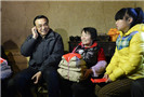
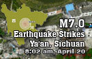
The 7.0-magnitude earthquake, which jolted Southwest China's Sichuan province on Saturday morning, has left 193 dead, 25 missing and 12,211 injured as of 6 a.m. Tuesday.
So far the rescue and relief teams have responded quickly mainly because the country has established an aerial intelligence network covering a large area and collecting precise information in an efficient way, Zhou said.
According to Zhou, shortly after the quake, the PLA Navy sent out its remote sensing aircrafts from the base in Sichuan to find out the situation of Lushan County, the quake epicenter and a remote mountainous region.
In the meantime, the PLA Air Force mobilized its helicopters and reconnaissance aircrafts to update the situation of the quake-hit areas and guide rescuers on land.
In most parts of Lushan, the strong quake damaged communication, transport and power supply facilities, adding difficulties for the rescue force who had to trek through narrow mountain roads and under the threat of landslides.
The BeiDou Navigation Satellite System (BDS) has enabled land rescuers to communicate among each other and with the headquarters, said Lang Anwu, chief of staff of an artillery regiment under the 13th Combined Corps of PLA Army, which has engaged in the rescue mission in Lushan.
The BDS is China's homegrown satellite navigation system. The country has already sent 16 satellites to space for the system and the BDS is expected to cover the globe with a constellation of over 30 satellites by around 2020.
"Each squad has been equipped with the BDS terminal device so that the headquarters can locate them at any time and send out orders," Lang said.
In the early hours after the quake, the transport of injured people and rescue teams has largely depended on helicopters and planes.
Three hours after the quake, a cargo plane took off to ship a national rescue team to the quake-hit area while four emergency helicopter squads rushed to the worst-hit areas to locate and set up temporary helipads.
In the first 72 hours since the quake, the air force shipped about 900 people out and more than 120 tonnes of relief material into the quake zone.
Since roads to some remote townships and villages were frequently blocked by sliding rocks, the Air Force started the first airdrop operation on Monday, delivering food and water for thousands of homeless survivors.
"The efficiency of rescue and relief work is closely linked to the capacity of air support," said Cai Suwei, a senior Air Force officer commanding the rescue work. "We need to further improve the fast response capacity of the Air Force so as to minimize the casualty in natural disasters."
A total of 19,000 soldiers and officers from China's military and armed police forces have been sent to quake-hit areas in Sichuan since Saturday.
Related readings:
Live report: 7.0-magnitude quake hits Sichuan
Premier urges full efforts to reduce deaths, injuries
Expert calls for rational volunteering, donations
Quake-hit region faces new threats
House damaged, life continues in Sichuan
Rescues continue as psychological support offered
China again thanks countries for quake assistance