New satellite keeps eye on sea interests
 |
|
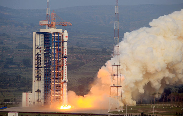
The Gaofen 3 high-resolution Earth observation satellite is launched on Wednesday morning. [Photo/Xinhua]? |
High-tech radar will also improve nation's ability to forecast, warn of natural disasters, experts say
China is putting its nearby waters under more effective surveillance with its newly operational high-tech satellite.
Launched on Wednesday morning, the Gaofen 3 high-resolution Earth observation satellite will help the nation beef up its capabilities to safeguard its maritime interests and to help forecast and warn of natural disasters, space program officials said.
The satellite was delivered by a Long March 4C rocket that blasted off from the Taiyuan Satellite Launch Center in Shanxi province.
It is equipped with a radar system that captures images from space with a resolution down to 1 meter, according to the State Administration of Science, Technology and Industry for National Defense, which oversees China's space programs.
The Gaofen 3, which was developed by the China Academy of Space Technology in Beijing, is capable of generating radar images in all weather conditions and can work around the clock.
The satellite will play an important role in monitoring the marine environment, islands and reefs, and ships and oil rigs, said Xu Fuxiang, head of the Gaofen 3 project at the academy.
He said that considering China has a total of 32,000 km of coastline, 380,000 square kilometers of territorial seas and more than 6,500 islands that have an area of at least 500 square meters, satellites like the Gaofen 3 will be very useful in safeguarding the country's maritime rights and interests.
The Gaofen 3 will also help in disaster forecasting, assessment and relief, which now heavily rely on imported satellite data, Xu added.
Gaofen 3 has a designed service life of eight years, said Liu Jie, Gaofen 3's chief designer at the China Academy of Space Technology. He added that the satellite is the best of its kind in the world in terms of technological level and imaging mode.
With 12 imaging modes, the satellite is able to take wide pictures of Earth and to photograph specific areas in detail, Liu said.
China launched the Gaofen project in May 2010 and has listed it as one of 16 key national science and technology projects. The aim of the Gaofen project is to form a space-based, high-resolution Earth observation network.
Gaofen 1 was sent into space from the Jiuquan Satellite Launch Center in April 2013. Four other Gaofen satellites were launched in 2014 and last year.
The Gaofen 5, 6 and 7 will be optical remote sensing satellites and are under development, according to the State Administration of Science, Technology and Industry for National Defense.
Currently, 26 provincial-level regions have set up Gaofen data application centers to receive and distribute images and data generated by Gaofen satellites, the administration said.
zhaolei@chinadaily.com.cn
- Gaofen-3 Earth observation satellite launched
- China launches hi-res SAR imaging satellite
- Agreement for BeiDou Naviation Satellite System data center signed
- From hunting wild fruits to satellite dishes: Life of Myanmar returnees
- China to launch 1st high-capacity broadband satellite
- Joint Sino-French satellite to study ocean waves, wind
- Is it a thing? 10 odd jobs where you can make good money
- Message on a bottle: Mineral water company launches drive to find missing children
- Sun Yat-sen champion of national integrity, unity: Xi
- Four killed, two injured after house collapses in C China
- Cross-Straits forum held to commemorate Sun Yat-sen


