According to Sun, there are about 20 routes reaching the top of Mt. Qomolangma, but the traditional route upon the north slope is among the safest ones.
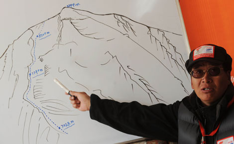 China mountaineering team spokesman Zhang Zhijian details on a diagram the proposed route for the Beijing Olympic torch's ascent of mountain Mt. Qomolangma, also known as Mt. Everest, at the Mt. Qomolangma base camp, Southwest China's Tibet Autonomous Region, May 7, 2008. Beijing Olympic torch relay will be taken to the world's highest peak by the traditional climb route along the north slope. [Xinhua]
 |
There are 28 km between the 5,200-meter-high Base Camp and the 6,500-meter-high ABC, and from the ABC, there are 20 km to the top.
"The snowfall several days ago had some impact upon the ascent, now our climbers are busy fixing the damaged facilities," said Zhang. "Yesterday, I heard that they have fixed the 7,790-meter-high camp, but I'm not sure whether or when they will take further action."
"If the weather looks good all the time these days, I think I will bring you good news as soon as possible."
One day earlier, Zhang named a 36-strong team, including 24 ethnic Tibetans, 10 Han Chinese, one from Tu ethnic group and one from Tujia ethnic group.
But he didn't give any information Wednesday about who will take the final assault, which means not all stands a chance of scaling the top of the Mount Qomolangma.
"The team is now discussing the final selection but it is still up in the air, but all climbers, no matter being picked or not, will deserve respect as he or she has contributed to the ascent," said Zhang.
"At last only a small portion of the climbers will relay the torch atop Qomolangma, but I hope the highlight will also be focused on those who gave all out to make it happen in different areas."
The Chinese Mountaineering Team has scaled Mount Qomolangma successfully for more than ten times since 1960.
According to a scientific measurement in 2005, the altitude of Mount Qomolangma is 8844.43 meters, 3.70 meters lower than the figure obtained in 1975.