Satellite network marks 5 years as guide


In the five years since its launch, China's domestically developed Beidou Navigation Satellite System has become a vital resource for public and commercial services nationwide, a senior official said.
The network is used to guide more than 4.8 million taxis, buses and trucks, as well as 40,000 fishing vessels, Ran Chengqi, director of the China Satellite Navigation Office, said on Wednesday.
He said in a news conference marking the fifth anniversary of the satellite system's launch that Beidou's accurate positioning and navigation services also have helped authorities respond to emergencies faster, including natural disasters.
More than 10,000 fishermen have been rescued or received assistance after using Beidou-enabled devices to send distress signals, he said at the Beijing news conference, organized by the State Council Information Office.
Beidou also has had an impact on everyday services. Ran said most shared bikes are connected to the network, while about 40 percent of smartphones on the Chinese market can access its services.
"In Beijing alone, 1,500 trucks, 33,500 taxis and 21,000 buses have end-user devices that can access real-time positioning and navigation," Ran said.
"Beidou has become a large industry-it has created more than 450,000 jobs in China and involves 14,000 domestic companies," he said. "Last year, the system had at least a 70 percent share of China's 211 billion yuan ($32.3 billion) space-based positioning and navigation market."
Beidou is the world's fourth navigation satellite system, following the United States-developed GPS, Russia's GLONASS and the European Union's Galileo.
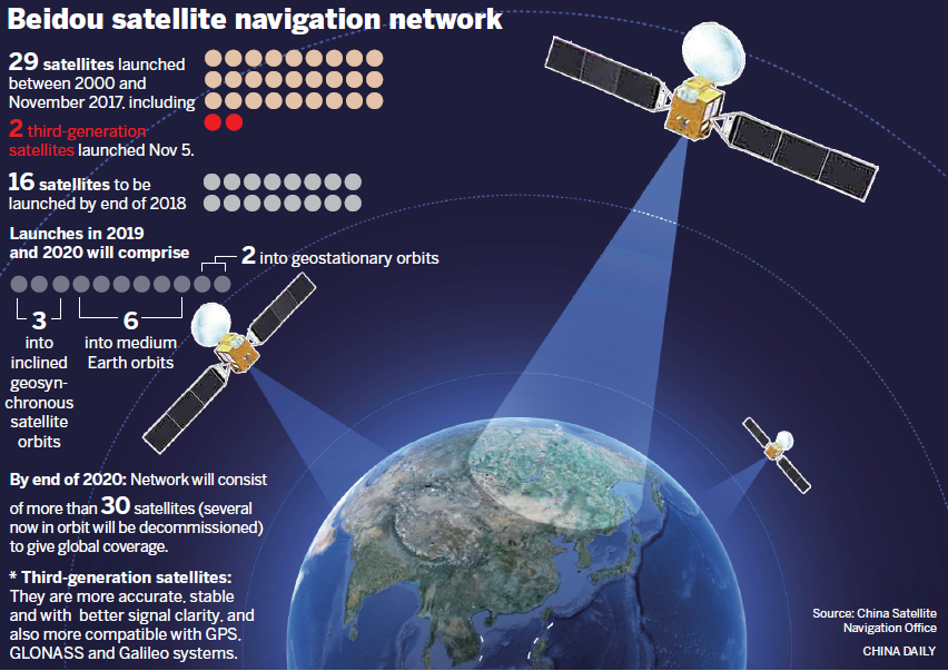
Twenty-nine satellites have been launched to form the Chinese network, the first in 2000 and the most recent in early November. The system began providing positioning, navigation, timing and message services for civilian use in China and parts of the Asia-Pacific region in December 2012.
Next year, 16 third-generation Beidou satellites will be sent into orbit to cover all nations involved in the Belt and Road Initiative, a far-reaching development plan proposed by President Xi Jinping in 2013 that includes the Silk Road Economic Belt and the 21st Century Maritime Silk Road.
According to plans from the China Satellite Navigation Office, the Beidou network will be made up of more than 30 satellites by the end of 2020-several now in orbit will be decommissioned by then-to give the system global coverage.
- Eight missing after cargo ship collides with fishing vessel near Shandong
- Investing in people: a worthwhile investment
- Exhibition commemorating the epic relocation of universities opens in Fujian
- Twelve punished for scaffold collapse that killed 7 in Shandong
- Slovenian official visits whole-process people's democracy practice site of CPPCC committees
- China's commercial rocket maker puts two satellites into orbit


