


Space for new discoveries


Space archaeology is a new branch of archaeology, with highly interdisciplinary attributes that link the natural sciences, sociology and humanities.
As a specialist in this new field of study, Wang says, to protect the cultural and natural sites, we also need to protect the environment around them.
"The task of space archaeology is to reveal the history, characteristics and patterns of human activities in the past, as well as to understand the evolutionary processes guiding the relationship between people and their environment," he says.
Before taking up research in remote sensing, Wang's specialty was geography and geology.
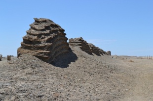
In 2013, Wang's team found five ancient city sites, the remains of more than 10 houses in two residential villages, one ancient channel site, one ancient road site and one pottery kiln site in Guazhou (Anxi)-Shazhou (Dunhuang) section of Gansu province along the major route of the ancient Silk Road.
This discovery, uncovered by using the remote sensing technology which provides abundant physical materials for the study of the history and geography of China's northwest frontier, fills the archaeological gap between sites from the Han Dynasty (206 BC-AD 220) and the Tang Dynasty (618-907) in the west of the ancient city of Bazhou.
"The sites of the places we discovered are in untraversed regions that are quite difficult for people to explore," Wang says. "Dry land is where remote sensing can make full use, especially in difficult-to-reach places."
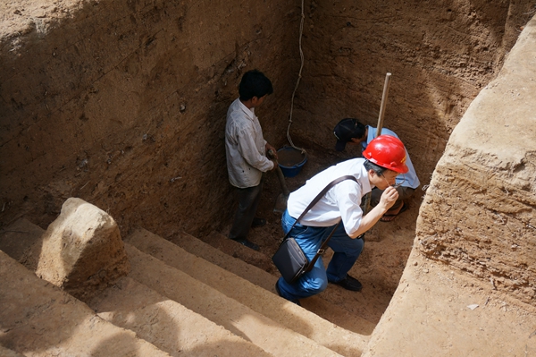
They first did literature analysis by researching historical documents about the route before using remote sensing to pinpoint areas they suspected could yield results. Then his team worked together with researchers from local museums in Gansu to conduct on-the-spot investigations to verify each site.
"When you are on the ground, it can be difficult to ascertain whether the course of a river is natural or human made, but with the help of the sensors mounted on the space-borne platform which provide a more macroscopic view, you can tell," Wang says.
"The visual field of people is limited, but the emergence of remote sensing technology has given them a pair of eyes in space."
The experience and success in Gansu gave Wang confidence when he led his team to research the project in Tunisia.
Inspired by one of Wang's international students, a Tunisian, the project soon became one of international cooperation.