Rescued desert cat given satellite positioning collar


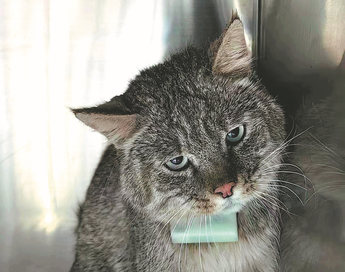
XINING — On the vast Jinyintan grasslands in the northwestern province of Qinghai, a fluffy Chinese desert cat named Huang Taiji is roaming around in search of prey. It is hard to believe this adorable, inquisitive feline was a scared, injured creature only a few months ago.
According to its rescuers, Huang Taiji was caught in a mousetrap while hunting for chickens in a herder's yard in Qinghai's Haiyan county in June. Listed as a national first-class protected animal in China, the Chinese desert cat is a precious feline species of great importance to ecological diversity.
Fortunately, the trap did not hurt the cat's bones, and it was soon rescued and transported to Xining Wildlife Park in Qinghai's capital city of Xining for treatment.
The park decided to release Huang Taiji into the wild after about a month of treatment and recovery. Together with researchers from the College of Veterinary Medicine of China Agricultural University, rescuers set the cat free on July 23. A satellite positioning collar was attached to the animal.
It was the first time a Chinese desert cat was released with a satellite positioning device attached to it, said Qi Xinzhang, deputy director of the park.
"The collar collects information concerning its latitude, longitude, altitude, temperature and even instantaneous velocity via GPS satellite positioning technology, and it uploads the data every two hours," Qi said.
Thanks to such information, Qi and his colleagues can effectively monitor the cat's condition and activities. "We can tell from the collected data whether the cat is captured or injured, and thus offer timely aid should any emergency happen," he added.
The collar not only provides researchers with quick solutions to save the cat's life. In addition, Qi is able to pinpoint Huang Taiji's movement range on a satellite map, which revealed a total range measuring about 200 square kilometers, while highlighting a 36-sq-km area where the cat spent most of its time." Previous research suggested that the average active area of Chinese desert cats was only about 3.3 sq km. With insights provided by the collar, we learned that the roaming area for the cat is much larger, shedding new light on related studies," Qi said.
Based on collected data, the park workers set up eight infrared cameras in the areas where Huang Taiji was most commonly found, and obtained lots of valuable information about the cat and other wild animals in the area. "We now have a better understanding of the living environment, diet and natural rivals of Chinese desert cats, all thanks to the collar," Qi said.
Satellite positioning technology not only offers a more efficient way to protect and study the Chinese desert cats, but is also empowering wildlife preservation in other places in China.
According to a report released by China's Beidou Navigation Satellite System, satellite positioning devices have been used for the protection and research of endangered animals ranging from Asian elephants to giant pandas. In addition to accurate positioning data, the system also offers innovative functions, including signal-free telegraph communication, enabling field researchers to track animals in remote areas.
Qi believes technologies such as satellite positioning are the future of wildlife preservation.
"We will keep releasing rescued Chinese desert cats fitted with satellite positioning collars, and initiate artificial breeding of these cats based on what we have learned," he said.
Xinhua


- National Games vibe is everywhere in Guangzhou
- Forum unites global experts to enhance city image communication
- Miao New Year celebrations get underway in Guizhou's Leishan county
- Mainland spokesman reiterates stand on Taiwan
- Fujian county's rural development becomes a big draw for Taiwan investors
- Nobel laureate in chemistry: Give young scientists more independence