Drones scour mountains to detect risks


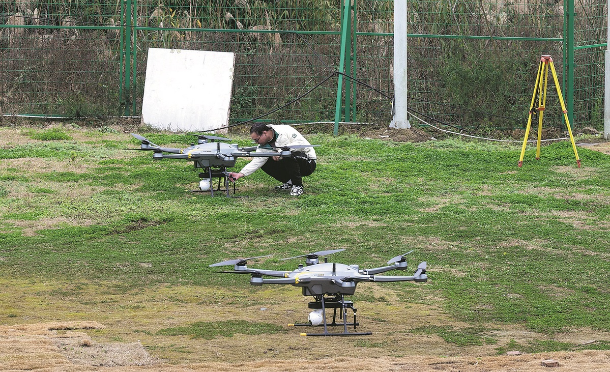
CHENGDU — In a move to combat natural disasters, Sichuan province has deployed an unmanned aerial vehicle network to monitor geological hazards across Pengzhou, a mountainous area prone to landslides and wildfires.
By late March, seven fixed-wing drone hangars and several multi-rotor systems will achieve full coverage of the area, transforming disaster response with 24/7 surveillance.
Developed by Chinese major commercial unmanned aerial vehicle company JOUAV, which is based in the provincial capital Chengdu, the drones are equipped with high-resolution cameras and advanced sensors, and are capable of cruising at 72 kilometers an hour with a 30-km operational radius.
Stationed at the Sky Eye No 3 base in Cifeng township in Pengzhou, located at the foot of a 780-meter-high mountain, these drones scan rivers, forests and slopes for anomalies, transmitting real-time HD footage and sensor data to command centers.
The system proved its worth during a landslide on Jan 27 in Cifeng's Luping community, where a 2,000-cubic-meter collapse damaged infrastructure. A pre-programmed fixed-wing drone detected the incident mid-patrol, enabling emergency teams to pinpoint the site within minutes.
"It's like having eyes in the sky. The drones act as aerial sentinels," said Zheng Wenqiang, head of the Cifeng operations base.
Notably, fixed-wing units can reach 120 km/h if needed, though their 70 km/h cruise speed already outpaces ground teams, said Zheng.
During this year's Spring Festival, the system slashed manual patrols in Cifeng from 50 workers doing 10-hour shifts to just seven technicians overseeing 20 daily flights.
Potential threats, from forest fire risks to trespassing, were identified 80 percent faster than what is possible via traditional methods, Zheng added.
The scope of these drones extends beyond disasters. They also monitor illegal logging, track lost hikers and even issue verbal warnings via onboard speakers when detecting wildfires or unsafe tourist behavior.
Live feeds allow officials to monitor traffic and crowds without having to conduct on-site inspections. "We'll build drone hangars at increased elevations in higher-altitude mountainous areas, thereby facilitating seamless drone launches," Zheng noted.
The first phase ensures a 10-minute response time in case of emergencies. Supplementary multirotor drones will enhance precision of collected data in urban zones, according to Zheng.
Once fully operational, the network will update data for the whole of Pengzhou on a weekly basis, while serving disaster response, law enforcement, traffic control, farmland protection, tourism oversight and urban management.
"When every second counts, these drones aren't just tools — they're lifelines," Zheng said.
Xinhua


- National Games vibe is everywhere in Guangzhou
- Forum unites global experts to enhance city image communication
- Miao New Year celebrations get underway in Guizhou's Leishan county
- Mainland spokesman reiterates stand on Taiwan
- Fujian county's rural development becomes a big draw for Taiwan investors
- Nobel laureate in chemistry: Give young scientists more independence